
Birch Groves on Candlewood Lake in New Milford, CT
Why Dock Houses Are So Rare on Candlewood Lake (And Why the Ones That Exist Are So Special)
Updated: January 2026
Context: I just posted a dock-house photo on Instagram here: Instagram post. This article is the deeper explanation people always ask about: “Why can’t you build these anymore?” and “What does the 440 line actually mean on Candlewood Lake?”
The short version
Dock houses are rare on Candlewood Lake because modern rules treat most “extra structures” near/over the water as a big deal. Candlewood isn’t just a recreational lake—it’s part of a regulated hydro project. That means shoreline structures are controlled through a combination of:
- FirstLight’s permit authority over “Project lands” within the shoreline boundary
- Federal oversight (FERC) tied to the lake’s hydroelectric license and shoreline management plan
- Connecticut environmental + local wetlands/zoning rules (especially within 200 feet of the lake)
- Deeded dock rights limitations (not every lot can add/expand docks)
So the dock houses you see today are typically older, grandfathered, or nonconforming “legacy” structures—the kind of feature that’s very hard (and often impossible) to replicate under today’s rules.
First: what is the “440 line” on Candlewood Lake?
If you’ve spent any time on Candlewood, you’ve heard people mention “the 440.” Here’s what it means in plain English:
- “440” refers to the 440-foot elevation contour (above sea level).
- Historically, the land below that contour was targeted as “lake land” when Candlewood was created—so the shoreline ownership and control is unusual compared to most lakes.
- In most cases, waterfront owners do not own down to the water’s edge. Their property typically ends at (or around) the 440 contour, and the land below is within the hydro project boundary.
The Candlewood Lake Authority’s lake history explains the 440-foot contour as the targeted “lake land” boundary during the lake’s creation: Candlewood Lake Authority – History of the Lake.
There’s also a helpful explanation (with context on typical summer lake levels) describing FirstLight’s shoreline ownership up to the 440-foot contour and the lake’s federal oversight: Esri ArcNews – Candlewood Lake Authority background.
Key numbers people confuse: The normal summer operating range is typically around 427 to 429.5 feet, while the “440 line” is about ~10–13 vertical feet above that range. (This is why you’ll see shoreline exposed during winter drawdowns and still hear people talk about the “440.”) Recent reporting on Candlewood’s operating elevations and drawdowns: CT Insider – Candlewood winter drawdown elevations.
Modern terminology note: People still say “the 440,” but you’ll also see it referred to as the Rocky River Project Boundary in some guidance, reflecting the hydro project’s boundary concept. (The practical takeaway is the same: there’s a regulated boundary zone where additional approvals often apply.)
Who is FirstLight, and why do they matter for docks and shoreline structures?
FirstLight Energy operates the hydroelectric system connected to Candlewood Lake (Rocky River pumped storage). Because Candlewood is part of a licensed hydro project, FirstLight has permit authority for uses and alterations on Project lands within the boundary.
FirstLight states directly that a permit is required for uses or alterations of Project lands, including building docks and other shoreline changes: FirstLight – Permits.
The Candlewood Lake Authority also points shoreline homeowners to FirstLight’s permitting process for dock changes and highlights the additional layer of local regulation within 200 feet of the lake: Candlewood Lake Authority – Shoreline Homeowners.
Translation: Even if your house is “waterfront,” a lot of shoreline/dock work involves approvals beyond “normal” private property improvements.
Why dock houses are different from “just a dock”
A floating dock is often treated as an access structure. A dock house (or anything that resembles a shed/cabana/covered structure at the water) starts to look like a building in a regulated shoreline zone.
That distinction matters because modern shoreline management guidelines commonly restrict features like:
- permanent roofs
- second stories
- electrical utilities
- expansions beyond defined dock size/length limits
For example, the Shoreline Management Plan guidance includes a clear statement that docks and stairs shall not have permanent roofs, second stories, or electrical utilities (among other constraints), reflecting the general direction of modern policy: Shoreline Management Plan (Proposed 2025 PDF).
Bottom line: A classic dock house is exactly the kind of structure modern shoreline rules try to prevent from proliferating.
One of the biggest “scarcity drivers”: deeded dock rights
On Candlewood, not every property automatically has the same right to install a new private dock. There’s a concept that comes up repeatedly in shoreline policy: deeded dock rights.
Federal materials tied to Candlewood’s management have described provisions that limit construction of new private docks to parcels where deeded rights to a dock exist—a major reason you don’t see “new everything” popping up around the lake: FERC document referencing deeded dock rights limitation (PDF).
FirstLight’s own “Overcrowding Plan” also discusses FirstLight’s ability to deny new dock permits where deeded rights do not exist, as part of broader overcrowding management: FirstLight – Candlewood Lake Overcrowding Plan (PDF).
Why this matters for dock houses: If expanding docks is already constrained by deeded rights and permit scrutiny, adding a “dock house” (more structure, more impact, more use intensity) becomes even harder to justify under modern standards.
Why existing dock houses feel so valuable (even when they’re “simple”)
Even a small, retro dock house changes the entire way a lake home lives. It’s not just “cool”—it’s functional:
- Everything lives at the water: life jackets, ropes, towels, floats, cooler, tools, dock lines.
- It turns the dock into a destination: shade, seating, sunset hangs, hosting.
- It reduces friction: fewer trips up/down the hill carrying gear.
- It’s an irreplaceable “legacy” feature: if you can’t easily build it today, it becomes scarcity-value.
Important note: Many legacy shoreline structures are treated as nonconforming uses. That doesn’t automatically mean “bad”—but it does mean a future owner should verify what’s permitted, what’s grandfathered, and what repairs/changes may require approvals through FirstLight and/or other authorities. (This is informational only.)
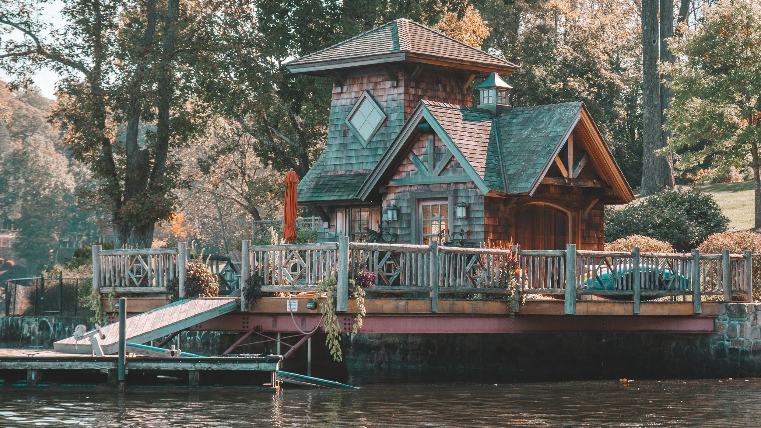
Real example: Birch Groves & the “retro dock house” vibe
Right next to the dock-house photo I posted, there’s a current listing in the Birch Groves community that shows exactly why people love this feature—an unmistakably retro dock-house setup that becomes a social hub all summer.
Listing reference: 23 Echo Dr, New Milford, CT (Zillow).
Photo credit: Photos of the retro dock house are credited to the listing company/MLS photography as displayed on the listing page.
FAQ (what people actually Google)
What does “440 altitude” mean on Candlewood Lake?
It refers to the 440-foot elevation contour that is commonly used to describe the project boundary/ownership/control line around Candlewood. In many cases, it marks where private property ends and the hydro project boundary begins—why shoreline work is regulated differently here. See: CLA lake history and Esri ArcNews overview.
Can you build a new dock house on Candlewood Lake today?
In general, it’s very difficult because modern shoreline rules restrict expansion of over-water/shoreline structures, and docks/shoreline work on Project lands require permitting through FirstLight (plus local/state review depending on scope). See: FirstLight permits and the shoreline guidelines: CLA shoreline homeowners page and SMP guidance PDF.
Why do people say Candlewood is “different” from other lakes?
Because it’s part of a pumped hydroelectric storage system under federal regulation, with a formal shoreline management framework. That changes the way docks and shoreline structures are managed compared to a typical privately owned shoreline lake. See: Esri ArcNews background.
Does a dock house add value?
Value depends on the specific property, condition, legality/grandfather status, and what buyers in that micro-location pay for. But as a concept, a dock house often carries a premium because it’s a rare lifestyle feature that’s hard to recreate under modern rules. (Informational only.)
License / representation note
I’m not a licensed real estate agent yet. This post is objective, informational, and based on publicly available materials about Candlewood Lake’s shoreline rules and management.
If you want the “dock house” lifestyle… what should you look for?
- Verify dock rights (deeded rights matter)
- Confirm shoreline/dock permits and any grandfathered/nonconforming status
- Ask what’s allowed to be repaired or replaced if the structure is older
- Understand seasonal water levels (winter drawdowns vs summer range)
If you liked the dock-house photo, I’ll keep documenting unique Candlewood features (communities, dock rights, shoreline rules, and lifestyle) on Instagram: See the post here.